
How satellites track the weather
- Large parts of North India, including states such as Bihar, UP, Uttarakhand, Haryana, Delhi, and Punjab, have been experiencing heavy fog since December 2023.
- IMD has been employing data from satellites like INSAT 3D and INSAT 3DR to monitor and communicate weather conditions, specifically focusing on fog alerts.
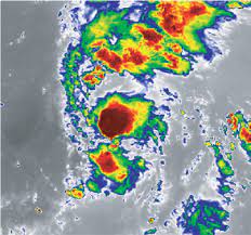
Satellite Maps and Their Interpretation
- The maps are generated by the INSAT 3D satellite, utilising an RGB imager that determines colours based on solar reflectance and brightness temperature.
- Solar reflectance is a ratio of the amount of solar energy reflected by a surface and the amount of solar energy incident on it.
- Brightness temperature relates to the object's temperature and the brightness of its surface.
- The colour composition is determined by three wavelengths viz. 0.5 micrometers (green), 1.6 micrometers (red), and 10.8 micrometers (blue), producing a detailed image.
Tracking Snow
- The maps help track snow by analysing solar reflectance and shortwave infrared radiation.
- Snow strongly absorbs radiation at 1.6 micrometers, making the red component of the colour scheme weak when the satellite tracks snow-covered regions.
Night Microphysics Data
- This component determines two colours based on the strength of the difference between two signals.
- Red colour is determined by the difference between thermal infrared signals at 12 micrometers and 10 micrometers.
- Green colour varies based on the difference between thermal infrared and middle infrared signals (10.8 micrometers and 3.9 micrometers).
- Blue colour is determined by the strength of a thermal infrared signal at 10.8 micrometers.
Applications and Weather Analysis
- The colour schemes aid in analysing different cloud types, initial stages of convection, maturing stages of a thunderstorm, identifying snow areas, and detecting fires.
- Combining day and night microphysics data helps atmospheric scientists study moisture droplets, temperature differences, and track the formation, evolution, and depletion of weather events.
Weather Satellite Data Collection
- INSAT 3D and INSAT 3DR use radiometers to make spectral measurements, capturing useful properties of radiation.
- Atmospheric sounders on the satellites measure temperature, humidity, and water vapour as a function of their heights from the ground.
- Combining radiometer and sounder measurements provides insights into various atmospheric characteristics.
Evolution of Weather Satellites in India
- INSAT 3DR's radiometer is an upgraded version of the Very High Resolution Radiometer (VHRR) used in earlier satellites like Kalpana 1 and INSAT 3A.
- The INSAT 3D and 3DR satellites are currently active in geostationary orbits around the earth.
- Each new satellite, including INSAT 3DS expected in February 2024, is an improved version, enhancing spatial resolution, spectral channels and overall functionality.
Conclusion
- Understanding satellite data plays a crucial role in monitoring and predicting weather conditions, enabling authorities to issue timely alerts and warnings to the public.
- The advancements in technology continue to enhance the capabilities of weather satellites, contributing to more accurate and comprehensive weather analysis.