
Geospatial Survey to Combat Illegal Mining in Aravallis
| Topic | Details |
|---|---|
| Event | Haryana orders a geospatial survey of the Aravallis near the Rajasthan border. |
| Purpose | To demarcate banned mining areas in Haryana and identify licensed mines in Rajasthan to curb illegal mining. |
| Conducted by | Haryana Space Applications Centre (HARSAC). |
| Key Objectives | Define jurisdiction of Haryana and Rajasthan over various hills and update revenue records. |
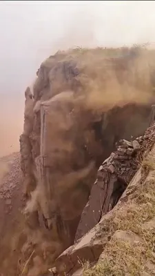
| Illegal Mining Issue | - Exploitation of jurisdictional ambiguity by illegal mining mafias.- FIR registered for illegal mining of 6,000 metric tonnes of hill in Rava village. |
| Illegal Mining Impacts | - Environmental degradation: deforestation, soil erosion, water pollution, habitat destruction.- Health hazards from use of hazardous chemicals like mercury and cyanide.- Loss of government revenue due to unpaid taxes and royalties.- Human rights violations: forced labor, child labor, exploitation of vulnerable populations. |
| Aravalli Range Details | - Extends from Gujarat to Delhi through Rajasthan, 692 km in length, 10 to 120 km in width.- 80% in Rajasthan, 20% in Haryana, Delhi, and Gujarat.- Divided into Sambhar Sirohi Range and Sambhar Khetri Range in Rajasthan.- Highest peak: Gurusikhar in Rajasthan at 1,722 meters. |
| Significance of Aravallis | - Prevents Thar Desert from encroaching on Indo-Gangetic plains.- Supports 300 native plant species, 120 bird species, and exclusive animals.- Directs monsoon clouds eastward, benefiting sub-Himalayan rivers and North Indian plains.- Shields fertile valleys from cold westerly winds in winter.- Aids groundwater replenishment by absorbing rainwater.- Acts as "lungs" for Delhi-NCR, mitigating air pollution effects. |