
**Yarlung Tsangpo Dam Project **
Context
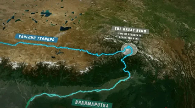
China is building a massive hydropower dam on the Yarlung Tsangpo River (upper stream of Brahmaputra) in Tibet, near the U-turn close to the India–Arunachal Pradesh border. This project is strategically located in a seismically active and ecologically sensitive region of the eastern Himalayas.
Geographical and Hydrological Significance
- Yarlung Tsangpo is the upper course of the Brahmaputra River, originating in western Tibet and flowing eastward before making a U-turn near the Namcha Barwa peak, entering Arunachal Pradesh as Siang, and then becoming Brahmaputra in Assam.
- This region hosts the world’s deepest canyon and is prone to glacial lake outburst floods (GLOFs) and earthquakes.
Dam Features and Comparison
| Feature | China’s Proposed Dam | India’s Response Dam (Arunachal) |
|---|---|---|
| Location | Medog County, Tibet, near India’s border | Upper Siang District, Arunachal Pradesh |
| River | Yarlung Tsangpo | Brahmaputra |
| Project Type | Hydropower + Storage | Run-of-the-river |
| Potential Output | Could surpass Three Gorges Dam | ~11,000 MW (planned) |
| Strategic Intent (China) | Energy security + territorial assertion | Counter-strategy + river rights claim |
Key Concerns for India
1. Disaster and Geological Risk
- Region lies in a high seismic zone → past example: 1950 Assam–Tibet earthquake (8.6 magnitude).
- Risk of earthquakes, landslides, and dam collapse with cross-border impact.
- Potential for flash floods or GLOFs, worsened by climate change.
2. Environmental and Ecological Challenges
- Disruption to biodiversity-rich Siang Valley.
- Alters sediment flow, aquatic life, and water temperature.
- Threatens riparian agriculture and fisheries in downstream Assam.
3. Geopolitical and Security Concerns
- Dam could be used as a “water bomb” by China during conflict.
- Strategic leverage over India in water resource diplomacy.
- Located near a militarized and disputed border (e.g., Tawang, Doklam proximity).
4. Cultural and Indigenous Rights Threats
- Threat to Adi, Mishmi, and other tribal groups in the Siang valley.
- Possible displacement and loss of sacred tribal lands.
Existing Cooperation Mechanism
| Mechanism | Details |
|---|---|
| Expert Level Mechanism (ELM) | Established in 2006 for hydrological data sharing during flood season |
| Coverage | Brahmaputra and Sutlej rivers |
| Limitation | No water-sharing treaty; only data sharing |
| Legal Position | Both India and China are not signatories to UN Watercourses Convention, 1997 |